There's a clear split in Ennis between the limestone bedrock hugging the west side near the River Fergus and the glacial drift covering the eastern approach roads. We see it on every project. A site off the Clon Road might hit gravelly sand at half a metre, while a plot near Quin Road hits a stiff boulder clay that holds water differently. That contrast is exactly why a simple borehole log sometimes misses the picture. An exploratory test pit lets the geotechnical engineer step into the excavation and see the transition zone with their own eyes. It is a direct observation method that maps the soil profile, identifies fill material from old Ennis developments, and records the groundwater table in real time. When the ground varies as much as it does across the Drumcliff and Doora areas, relying solely on point data from rotary drilling invites surprises during bulk excavation.
A single well-logged test pit in the Fergus floodplain can reveal more about the local soil architecture than three boreholes spaced ten metres apart.
Methodology applied in Ennis
Critical ground factors in Ennis
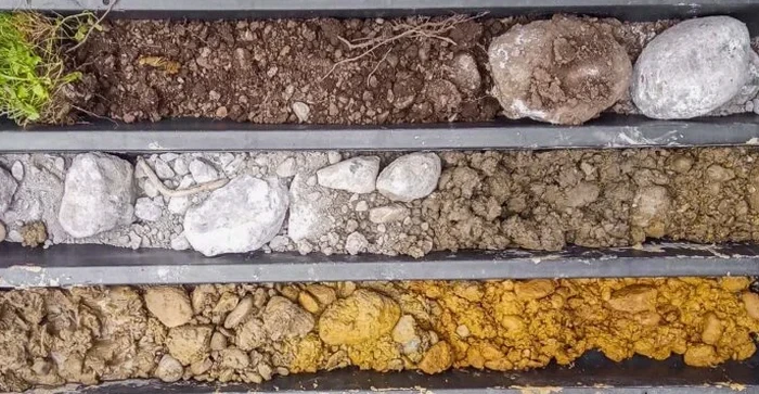
Under IS EN 1997-2:2007, the ground investigation must provide a continuous model of the subsoil conditions. In Ennis, this is especially critical because the town sits on the edge of the Clare limestone basin, where infilled solution features and soft alluvial pockets are common along the Fergus floodplain. We have opened test pits near the N85 that exposed a clean limestone surface at one end and a two-metre lens of compressible silt at the other, all within a ten-metre run. Contractors who skip the test pit stage here often hit that kind of variability during foundation excavation — and that triggers redesign, delay claims, and a costly re-mobilisation of plant. The exploratory pit gives the engineer a three-dimensional view of the deposit, which allows us to specify an appropriate bearing stratum or recommend a ground improvement method before the first bucket goes into the ground.
Our services
Our Ennis-based exploratory test pit service covers four core activities. Each one is designed to give the design team the visual and tactile evidence needed to make confident geotechnical decisions.
Trial Pit Excavation & Logging
Mechanical excavation using a backhoe or mini-excavator, with continuous logging by an engineering geologist. We record strata boundaries, colour, consistency, and moisture condition against the IS EN ISO 14688-1 standard. Photographic records are taken at each metre interval.
In-Situ Strength Assessment
Direct measurement of undrained shear strength using a hand vane and pocket penetrometer on the pit walls and floor. This gives immediate data on the bearing capacity of cohesive layers, which feeds directly into the foundation design for Ennis housing schemes.
Groundwater Monitoring Installation
Where the pit reveals a shallow water table, we install a standpipe piezometer before backfilling. This allows long-term monitoring of groundwater fluctuation, which is critical for basement design and SUDS drainage assessment in the Ennis urban area.
Disturbed & Undisturbed Sampling
Collection of bulk samples for classification testing and block samples for strength testing. We coordinate directly with the laboratory for grain-size analysis and triaxial tests, ensuring chain of custody from the Ennis site to the lab is documented.
Questions and answers
How much does an exploratory test pit cost in Ennis?
For a standard trial pit in the Ennis area, you're looking at a range of €410 to €840 per pit. The final figure depends on access conditions, depth required, the presence of any underground services that need daylighting, and whether we install a piezometer. We quote per pit as part of the overall ground investigation scope.
What is the difference between a test pit and a borehole?
A test pit is an open excavation that lets the engineer see the soil fabric, bedding, and fissuring directly. A borehole recovers a disturbed or cored sample from a narrow diameter. Pits are best for shallow investigation down to about 4.5 metres, especially where you need to map lateral variation across a site in Ennis.
Do you need a road opening licence for a test pit in Ennis?
If the pit is within the public road boundary, yes — a road opening licence from Clare County Council is required. We manage that application for you, including the traffic management plan and the temporary reinstatement specification. Private land pits do not need a licence.
How long does a test pit stay open before you backfill it?
Most pits are logged, sampled, and backfilled the same day. If groundwater monitoring is specified, we might leave the pit open for up to 24 hours to check the recovery rate. We never leave an unattended open excavation on site in Ennis — safety fencing and backfill are part of the same-day procedure.