Ennis sits at an elevation of just 3 meters above sea level on the River Fergus floodplain, which means groundwater is often encountered within the first two meters of drilling. When the county council approved the new 6-story mixed-use block near the Fair Green in 2023, the geotechnical brief specifically required SPT data with energy-corrected N60 values because the alluvial silts beneath the town center have produced widely scattered blow counts in past investigations. Our laboratory processes the split-spoon samples from each SPT drive immediately after extraction, logging moisture content, color changes, and shell fragments that often indicate the transition from river terrace deposits into the underlying glacial till. For deeper profiling in the drumlin-affected areas west of town, we sometimes combine the SPT program with a CPT test to verify the continuous stratigraphy where the till matrix includes cobbles that can deflect the split spoon.
An uncorrected N-value is just a number. The engineering value comes from applying hammer energy ratio, overburden pressure, and borehole diameter corrections before it enters a foundation calculation.
Methodology applied in Ennis
Critical ground factors in Ennis
During a warehouse project on the Gort Road industrial estate, the initial desk study suggested uniform gravelly sand to 10 meters depth. Our SPT investigation revealed a 1.8-meter-thick lens of soft organic silt at 4.5 meters depth with N-values of just 3 to 5 blows per 300 mm, a layer that would have caused differential settlement severe enough to crack the slab-on-grade within the first two years of operation. This is the reality of working in a river floodplain town like Ennis: buried paleochannels and abandoned meanders create sharp lateral changes in soil stiffness that only a closely spaced SPT grid can detect. Overlooking these soft spots because the overall site geology looks favorable on a regional map is a risk that translates into expensive underpinning work later, and in the worst case, structural distress in the steel frame.
Our services
Our Ennis-based SPT service includes the full chain from drilling to laboratory classification and engineering interpretation, all under one quality management system.
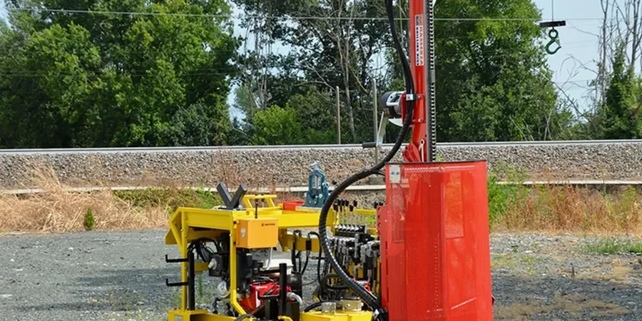
SPT Drilling and In-Situ Testing
Mobile rotary drilling rig with automatic trip hammer, calibrated to measure hammer energy ratio on site. We log groundwater strikes, casing depths, and any drilling fluid losses that indicate karst features in the limestone. Each SPT sample is sealed immediately in a plastic liner to preserve natural moisture content for laboratory index testing.
Geotechnical Interpretation Report
The SPT data alone is not enough—our report delivers N60 profiles, estimated relative density, friction angle correlations (Hatanaka & Uchida, 1996), and settlement predictions using Schmertmann's method where applicable. We provide direct input parameters for shallow and deep foundation design, along with recommendations for any supplementary testing if the SPT results indicate problematic soils.
Questions and answers
How much does an SPT investigation cost for a typical site in Ennis?
For a standard SPT investigation in the Ennis area, including rig mobilization within County Clare, drilling to 10 meters depth with SPTs at 1.5 m intervals, and a factual report with N60 profiles, the cost typically ranges from €530 to €630 per borehole. The final price depends on access conditions, the number of boreholes, and whether the glacial till requires heavy-duty casing to stabilize the hole.
What is the difference between raw N-values and N60 values?
Raw N-values are the uncorrected blow counts recorded in the field. An N60 value is the blow count corrected to a reference hammer energy efficiency of 60% of the theoretical free-fall energy, following the procedures in I.S. EN ISO 22476-3. This correction is essential because automatic trip hammers, safety hammers, and donut hammers deliver different amounts of energy to the drill rod, and without the correction, two rigs testing the same soil can give different N-values.
How deep do you typically drill for an SPT in the Ennis area?
Most SPT boreholes in Ennis extend to between 8 and 15 meters depth, depending on the foundation type and loading. For a two-story residential extension on the Limerick Road, 8 meters is often sufficient. For a multi-story commercial building near the town center, we typically go to 15 meters or until we encounter competent limestone bedrock with N-values above 50 for at least 1.5 meters of continuous refusal-level material.
Do you need any special permits to drill SPT boreholes in Ennis?
Yes, any borehole deeper than 2 meters in Ireland requires a GSI (Geological Survey Ireland) borehole notification. Our team handles this notification as part of the project setup. Additionally, if the site is near a protected structure, an archaeological zone, or within the River Fergus floodplain, we coordinate with Clare County Council to ensure all planning conditions related to ground investigation are satisfied before drilling begins.
Can SPT data be used to estimate the bearing capacity of a foundation?
Absolutely. SPT N60 values are one of the primary inputs for empirical bearing capacity methods used under Eurocode 7. For granular soils, correlations such as those by Bowles (1996) and Meyerhof (1965) allow estimation of allowable bearing pressure for a given settlement limit, typically 25 mm. For cohesive soils, the SPT provides an index of consistency that can be correlated to undrained shear strength using relationships by Stroud (1974), though we often recommend supplementary triaxial testing for critical structures.