The most common error we see in Ennis is treating a slope cut in glacial till the same as one in fractured limestone. The River Fergus floodplain has a thin veneer of alluvium, but move a few hundred meters toward the drumlin swarms around Drumcliff and you encounter entirely different soil mechanics. A cut that stands perfectly through a dry summer can unravel after a single wet winter if the pore pressure regime isn't modeled correctly. For a population of 25,000 expanding toward the Quin Road corridor, proper slope stability analysis separates projects that get built on time from those that stall after the first heavy rainfall. Our laboratory, accredited to ISO 17025, performs both drained and undrained shear strength testing on undisturbed Shelby tube samples extracted from the very slope under investigation. The output feeds directly into limit equilibrium models that incorporate the specific hydrogeological conditions of County Clare, where the interface between glacial deposits and the underlying Dinantian limestone often controls the failure surface. We combine this with detailed test pits to map the depth of weathered bedrock, a critical parameter when designing cut slopes near the M18 embankments.
A slope that holds in August can fail in January — not because the soil changed, but because the pore pressure regime did.
Methodology applied in Ennis
Demonstration video
Critical ground factors in Ennis
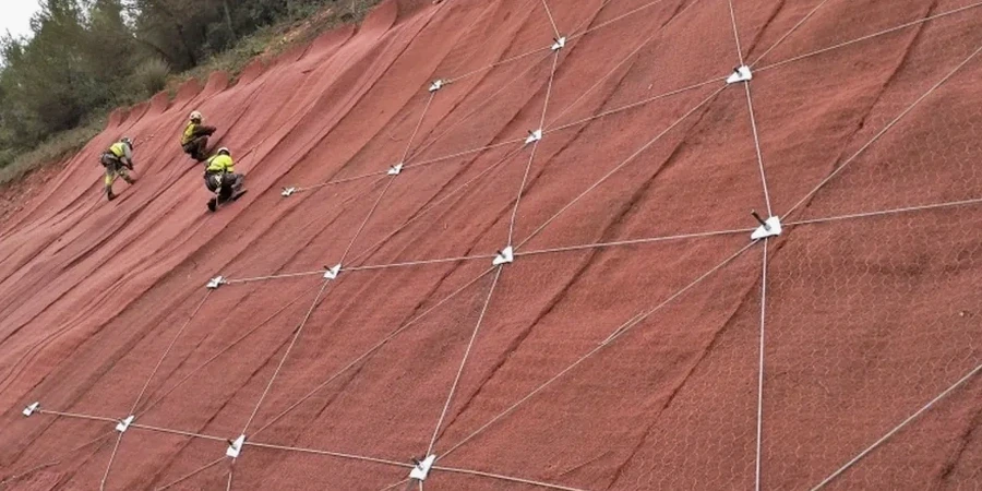
Compare the steep valley sides of the River Fergus upstream of Ennis with the flatter drumlin topography toward Crusheen. The former exposes near-vertical limestone bluffs where stability is governed by joint orientation and the potential for wedge failure along intersecting discontinuities. The latter presents a subtler hazard: rotational slides in the silty matrix of the till that can retrogress uphill, threatening property boundaries that were drawn decades ago without geotechnical input. The Corrovorrin area, with its mix of older housing and newer infill development, sits on a slope that has shown creep movement in LiDAR surveys — slow enough to go unnoticed year by year, but real enough to distort retaining walls and crack service pipes over a decade. In Ennis, ignoring a slope stability analysis before excavating or building above a 3-meter cut is not just a specification gap; it exposes the developer to liability under the Safety, Health and Welfare at Work (Construction) Regulations. Our reports include a sensitivity analysis that quantifies how much the factor of safety drops if the water table rises by just 1 meter — often the difference between a stable slope and a failure.
Our services
A slope stability analysis is not a single calculation but a phased investigation that builds from desk study to detailed laboratory testing and computational modeling. The following service tiers are designed for Ennis's specific geological setting, where karst features in the Burren formation and the variable thickness of glacial drift create a geotechnical profile that demands more than a generic approach.
Deterministic Limit Equilibrium Modeling
Full analysis using Spencer and Morgenstern-Price methods for non-circular slip surfaces, calibrated with laboratory-measured shear strength parameters from your site. Includes pore pressure distribution modeling using the Ru coefficient or steady-state seepage analysis, and a parametric study varying water table position to bracket the realistic factor of safety range for Ennis's seasonal groundwater fluctuations.
Rock Slope Kinematic Assessment
For cuts in the limestone bedrock common around Ennis, we perform stereonet analysis of joint sets from scanline surveys, evaluating planar, wedge, and toppling failure modes. Combined with laboratory tilt tests on rock joints to determine basic friction angle and JRC roughness correction, this analysis defines the safe cut angle before any support is installed.
Slope Instrumentation and Monitoring Plan
Installation design for standpipe and vibrating wire piezometers, inclinometer casings, and survey prisms to track movement during construction and the first critical winter cycle. The monitoring data feeds back into the geotechnical model, allowing the design to be validated against real pore pressure and displacement data and adjusted before progressive failure can initiate.
Questions and answers
How much does a slope stability analysis cost for a typical residential site in Ennis?
For a single residential plot requiring a cut or fill slope assessment, the analysis typically ranges from €1.080 to €3.450 depending on slope height, the complexity of the ground profile, and whether site-specific laboratory shear strength testing is needed. A small cut under 3 meters on competent till with a desk study and a single analysis run falls at the lower end; a higher slope with multiple soil layers, piezometer monitoring, and several failure mode checks moves toward the upper range. This includes the factual report with factor of safety calculations compliant with Eurocode 7.
What is the difference between a slope stability analysis and a retaining wall design?
The slope stability analysis determines whether an unsupported slope is inherently stable under its own weight and groundwater conditions, calculating the factor of safety against collapse. A retaining wall design starts where the slope stability analysis shows an unacceptable factor of safety: it engineers a structural element to provide the additional resisting force needed. In practice in Ennis, many projects require both — first we quantify the instability in the natural or cut slope, then we size the retaining structure to bring the global factor of safety above 1.40 for permanent conditions.
Do I need a slope stability analysis for a site that has been stable for 20 years?
Stability over 20 years tells you the slope was stable under the groundwater and loading conditions of those two decades, but it does not guarantee future stability if conditions change. Excavating at the toe, adding fill at the crest, or altering drainage patterns can destabilize a slope that has been dormant for decades. In Ennis, many slopes in glacial till are at factors of safety between 1.0 and 1.2 — metastable, but not safe for construction that changes the geometry or the pore water regime. A re-analysis quantifies how much additional stress your proposed works will impose on that slope.
How long does a full slope stability analysis take from investigation to report?
A typical timeline for a project in Ennis is 4 to 6 weeks from the start of site investigation to the delivery of the interpretive report. The first week covers the desk study and site reconnaissance to plan the investigation. Drilling, sampling, and piezometer installation take 1 to 2 weeks depending on access and ground conditions. Laboratory shear strength testing on the recovered samples runs 2 to 3 weeks to allow for consolidation and staged shearing. The limit equilibrium modeling and reporting is completed in the final week. Rush turnaround can compress this to 3 weeks for simple, low-height slopes where triaxial testing is not required.